Tag: pedal

Some cycle routes are more practical than others

As part of the planners’ aim for Wichelstowe to be a so called sustainable development, the original masterplan makes plenty of provision for cyclists. Not all of it is entirely practical though. I’m not the first to comment on the cycle route along Peglars Way and Foxham Way. Others passed this way a year ago and were not wholly impressed. A year later and they still weren’t happy.
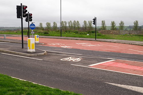
Some cycle routes are more practical than othersApproaching along Foxham Way from Mill Lane, after negotiating a roundabout with raised cobbles, the cycle lane starts in the middle of the road. To use this cycle lane one has to ride down the central bus lane, marked red to the right of the short cycle lane, in order to hit the pads in the road that work the traffic lights, then do a sharp right turn to hit the cycle lane pads. It might be worthwhile if it were not that the cycle and bus lane ahead is rather short, crossing back over the road a couple of hundred yards further on. At that second junction there are again traffic lights, but with a very long gap between them turning red for motorists on Foxham Way and turning green for cyclists and buses heading for East Wichel Way. I’ve now seen several motorists stop for the red light then, noticing there is no bus waiting to cross, get impatient and drive on. For cyclists content to disregard road markings, ignoring the cycle lane, heading straight on along Foxham Way and then turning left (against the road markings) into East Wichel Way is far quicker, and probably no less safe.
Dissuasion

Whilst looking through the current crop of planning applications, having perused the application to build 210 houses near Lydiard Park which is causing some concern locally, my attention was drawn to a somewhat more remote application. In fact not just remote, but positively out-of-the-way.

Comwood (London) Ltd have applied to build twenty affordable houses at Langton Park. That’s up the hill from Wroughton, near to one of the side entrances to Wroughton Airfield. It’s quite some hill and for pedestrians or pedal cyclists the climb from Wroughton is not for the faint hearted — fine if you’re reasonably healthy, but not otherwise. Naturally, the architects take a rather more positive view of things.

The guidance document also outlines that cycling can replace car trips up to 5km. The proposed development site offers good cycle links to local amenities and employment in Wroughton. Footways are present along most lengths of the private roads surrounding the site, although there are no signed cycle routes. However, the roads are relatively wide and are lightly trafficked, which is ideal for pedestrians and cyclists.

So that’s not specifically a cycle link at all, just an ordinary road. And the roads are only ‘relatively wide and lightly trafficked’ within the Thorney Park, Langton Park and Alexandra Park areas. Head towards Wroughton from Thorney Park or Langton Park and the roads are much narrower and without footways.

The nearest post office (Wroughton Sub-Post Office) being some 2.3km (1.4 miles) distant, can be reached in approximately 12 minutes, assuming a cycling speed of 12km (7.5mph)…. Account has also to be been taken of the topography, which is downhill heading towards Wroughton. The topography may or may not dissuade some potential cycle users.

May or may not dissuade? As an occasional recreational cycle ride, fine. As a regular commute to the ‘employment in Wroughton’, a hard slog up Prior’s Hill is not what I’d want after a hard day’s work. Correspondence on the application suggests that Swindon Borough Council’s planning department are no more convinced than I am.

Both the Langton Park and Grange Park proposed developments are outwith the boundaries specified in planning policy for development. Sadly, the developers’ inventiveness in reinterpreting those policies knows no such bounds.

No easy ride on Route 45

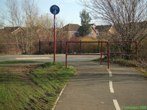
Cycling obstacle courseRoute 45 at Mouldon HillI have previously commented on the silliness of some of the obstacles placed in the way of cyclists in Swindon. Today I came across one such obstacle at Taw Hill, on National Cycle Route 45. The route is newly signposted, with the signs indicating that it’s just 13 miles to Cirencester and, for the more energetic, 48 to Gloucester. But with pointless obstacles like the one shown — everyone, including me, cycles round, chewing up the grass — it wouldn’t be the quickest of journeys.

Surely there are more effective ways to slow careless cyclists whilst allowing more careful riders on their way relatively unimpeded.

Steeplechasing, cycle-style

Anyone using the cycle routes in Swindon will be accustomed to the sort of obstacle in the photograph. They’re usually at the junction between a cycle route and a road, presumably to stop children riding straight onto the road without looking. A child on a bicycle could, just, negotiate their way around the zig-zag of barriers. For an adult the only way is to push their bicycle through or, where there is open space (as there is for most examples in north Swindon), ride round the outside, thereby making the whole thing totally pointless. The example here is one I came across today on Whitehill Way in Freshbrook, at the highly dangerous junction of… one cycle path with another cycle path. Apart from the possibility that whoever was responsible for this would like to start a new type of steeplechasing event using bicycles, just what is the point?